
Californians Deserve to Know Where Their Cell Phones Work
Can you hear me now? For those of us who remember the cell phone commercials of the early 2000s, it’s a familiar refrain. And despite decades of advances in wireless technology, many of us still find ourselves wandering around the house or stepping outside in hopes of finding a better signal. It’s a familiar frustration, but it points to a larger problem: We often don’t know where our wireless service will actually work until we try to use it.
The thing is, wireless companies have detailed information about where their signals are expected to reach and how strong those signals will be. But customers don’t have access to that same information. Instead, we’re left relying on colorful coverage maps that suggest where service is available without necessarily telling us where we can reliably place a call.
And this is about more than inconvenience. More than 80 percent of 911 calls in California are now placed from a wireless device. If a wireless signal cannot reach inside the customer’s home, they may not be able to call for help in an emergency.
The California Public Utilities Commission (CPUC) has an opportunity to make this information more accessible and transparent to the public. In its wireless service quality proceeding, a CPUC staff proposal recommends requiring wireless companies to make more detailed coverage maps available to customers. The Public Advocates Office applauds this direction and agrees with the simple premise: If companies already know where service is expected to work, customers deserve to know too.
What is the wireless service quality proceeding?
For decades, California has had enforceable minimum standards for landline telephone service. These rules address basic customer protections, such as how quickly companies must install service and restore service after outages, and how long a customer can be left on hold. In September 2025, the CPUC extended service quality standards to certain Voice over Internet Protocol (VoIP) services in General Order 133-E, which takes effect in January 2027.
Opened in February 2026, the CPUC’s wireless service quality proceeding is examining which existing service quality rules should apply to wireless voice service, and what new standards, performance measures, or reporting requirements are needed. These protections are important because most Californians now rely on wireless voice service for their everyday communication needs, including access to emergency services.
The CPUC has not yet made a final decision in the proceeding, but the staff proposal recommends several protections for wireless customers, including requirements to:
- Restore service within 24 hours when an outage isolates a community.
- Keep networks available 99 percent of the time, measured locally so poor performance in rural communities cannot be masked by stronger performance in more populated areas.
- Answer 80 percent of customer service calls with a live representative within 60 seconds.
- Publish accurate maps that show where a customer can reliably place a voice call.
The Public Advocates Office supports each of the above standards. From 2023 through 2025, outage data show that more than 1,000 wireless service outages in California lasted longer than 24 hours, including 359 that lasted longer than 72 hours. Wireless companies describe this as a small percentage of overall network operations. However, for communities that experience these outages, the inability to call 911 is a serious concern.
What Coverage Maps Don’t Tell Customers
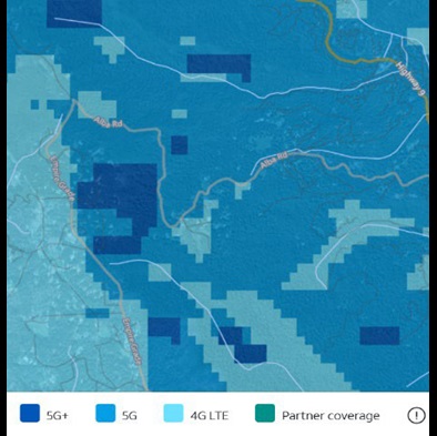
The coverage maps that companies publish today only tell customers where technologies such as 5G and 4G LTE are expected to be available. These maps are primarily designed to advertise service, not to provide detailed information about signal strength and call reliability – essentially where a wireless call can actually be made.
Despite having the data, companies do not make this information readily available to customers. Before a company builds a cell site, its engineers model how far the wireless signal will travel and how strong it will be on the ground, accounting for terrain, trees, buildings, antenna height, and transmission power. These maps are called “signal propagation maps” and are used to select tower locations and designed to support applications for local government permits. However, these signal propagation maps are very different from the maps companies use to advertise their service.
In fact, when you compare the Carrier Coverage Map (left) with the Detailed Signal Strength Map (right), submitted for a proposed new cell site in the same general area, you see a very different picture of wireless coverage. While the Carrier Coverage Map shows broad areas of expected 5G and 4G LTE availability, the Detailed Signal Strength Map shows how much signal strength can vary across the landscape. Green indicates stronger signals expected to support calls indoors, yellow indicates signals expected to support calls from a vehicle, and blue indicates weaker signals that may support calls outdoors but are not expected to provide reliable indoor coverage. This more detailed information can help customers better understand where they may experience coverage issues – something that isn't apparent from the Carrier Coverage Map alone.
Carrier Coverage Map
Detailed Signal Strength Map
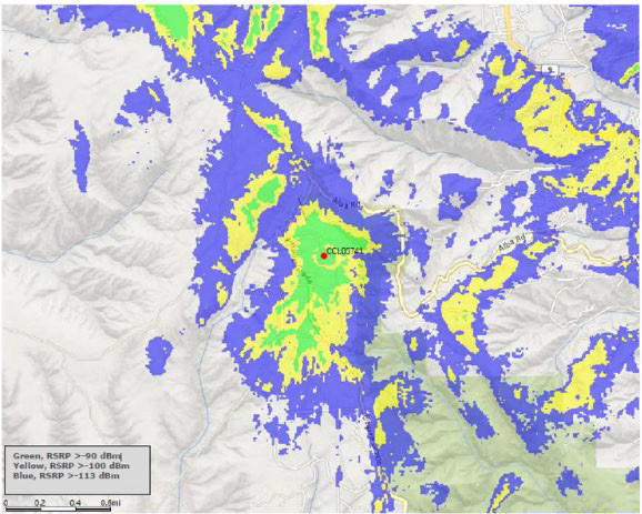
Source: Public Advocates Office presentation at the CPUC Wireless Service Quality Workshop, June 25, 2026, page 129. The detailed signal strength map was submitted with permit documents for a proposed new cell site.
By adopting the staff proposal to require companies to make signal propagation maps available to customers, the CPUC can help customers make more informed decisions about their service. This transparency is especially important as companies transition from traditional copper networks to fiber and wireless technologies (see our work on Carrier of Last Resort (COLR)) Customers should have the information they need to assess whether wireless service can meet their communication needs before their landline service is disconnected.
Why Wireless Companies Oppose More Detailed Coverage Maps
AT&T, Verizon, T-Mobile, and CTIA have opposed the propagation map requirement contained in the CPUC’s staff proposal. In general, they argue that this information is already collected by the Federal Communications Commission (FCC). They also assert that requiring them to disclose where their service will and will not work would violate their First Amendment rights.
Although the FCC collects propagation data, its public-facing National Broadband Map shows mobile broadband coverage rather than whether customers can reliably make wireless voice calls indoors. The FCC also makes mobile voice coverage data available for download, but those maps do not establish indoor call reliability.
Broadband data connectivity is very different from voice connectivity because voice calls require consistent, real-time communication, while many data applications can tolerate short delays or interruptions. Voice calls can become unintelligible or disconnected entirely because of signal disruptions that may be less noticeable when using data services.
Although more detailed coverage information is available in some international markets, including the European Union, U.S. customers still lack easy-to-use information that helps them assess where wireless calls are likely to work reliably. The CPUC is poised to help close this gap in consumer transparency.
Ultimately, the CPUC should adopt the staff proposal. Because wireless companies already develop detailed coverage information, Californians should be able to determine, before they sign a contract and certainly before their landline is disconnected, whether wireless service can meet their critical communication needs. No one should have to discover a gap in coverage when they need to make an emergency call.